Scientists claim they have been able to solve the mystery of the spiral openings Puquios near the Nazca desert in Peru. The BBC reports that the discovery was made possible thanks to satellite images.
In the past, scientists believed the Nazca geoglyphs, appearing in the form of people, animals and mythical characters actually served the purpose of an ancient irrigation system. But a possible explanation for the mystical spiral holes in the ground did not exist until now.
Scientists have previously attempted to explore Puquios, unsuccessfully due to the inability to use radiocarbon methods to study the tunnels. The ancient Nazca civilization left no clues behind to help understand the origin of these spiral holes. Like many other ancient South American cultures, save for the Mayans, the Nazca did not have any recorded script.
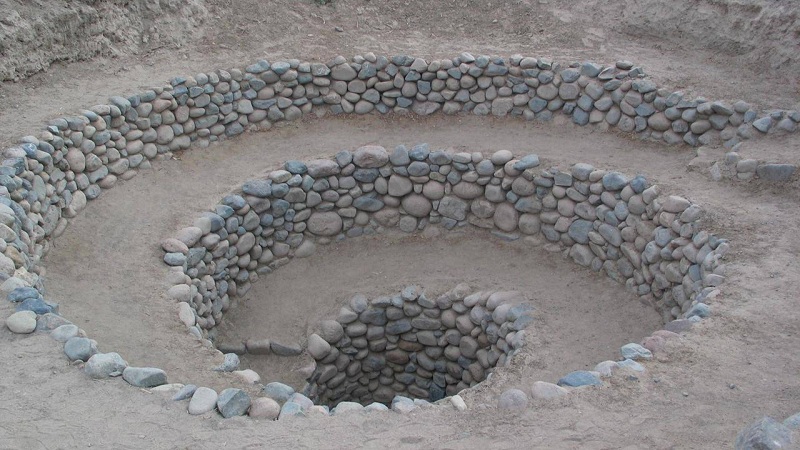
As explained by Rosa La Saponara from the Institute of Methodology and Environmental Analysis in Italy, the Puquios spiral holes were actually a part of an ancient, complex hydraulic system designed to extract groundwater.
According to La Saponara, examining the satellite images has allowed scientists to analyze the location of the spiral holes, while at the same time learning about the movement of water in the desert.
All holes were interconnected via a system of tunnels, similar to modern subways. Each spiral hole appeared to serve the function of a pump, filling the tunnels with air and directing the water to a specific location. In this way water flowed to the ancient settlements where it was used for the everyday needs of its people.
Scientists maintain the engineering system was built to such high quality that many of the Puquios spiral holes can likely still function perfectly even today.
To build them in the ground, the Nazca people needed not only special equipment, but also a deep understanding of geology and the movement of groundwater, since parts of the tunnels passed through tectonic faults.
Furthermore, there must have been a system that serviced these so-called „air wells“.
Rosa La Saponara does not exclude the possibility that the spiral holes may have been connected to the geoglyphs of the Nazca people. Furthermore, she believes such a system in their culture could have played a political role too: those in power could control the volumes of water distributed among municipalities and thus maintain the existing social order.
The Nazca civilization existed on the southern coast of Peru from the II century BC. to VI century AD. The Geoglyphs of the Nazca were a group of giant geometric shapes in the desert in southern Peru.
Scientists have been able to discern and count around 30 shapes, including a bird, a monkey, a spider, flowers and so on. In addition to this, around 700 geometric shapes, including triangles and trapezoids are also connected to the geoglyphs.
The shapes reach a length of several hundred meters, so they were noticed only after the first aerial picture was ever taken during the first half of the twentieth century. A detailed map depicting all Peruvian geoglyphs is yet to be discovered. At a different time, scientists have thought the geoglyphs may have been an astronomical calendar or religious symbols.